
Simanaitis Says
On cars, old, new and future; science & technology; vintage airplanes, computer flight simulation of them; Sherlockiana; our English language; travel; and other stuff
ON GERRYMANDERING
MERRIAM-WEBSTER DEFINES “to gerrymander” as “1: to divide or arrange (a territory) into election districts in a way that gives one political party an unfair advantage.” and “2: to divide or arrange (an area) into political units to give special advantage to one group.”
It also leads to some real contortions of the body politic. Here are tidbits gleaned from my usual Internet sleuthing.
The Effects of Gerrymandering. Wikipedia offers a straightforward example:
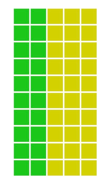
This rectangular array of 50 precincts happens to be politically aligned 60-percent Yellow and 40-percent Green. It’s to be apportioned into five districts, each with ten precincts. each.

The one on the left has geometrically simple districts, but its “Yellow Wins All” ignores those Green voters. The more complex districting on the right gives Green a majority, which, in a sense, is even less fair.
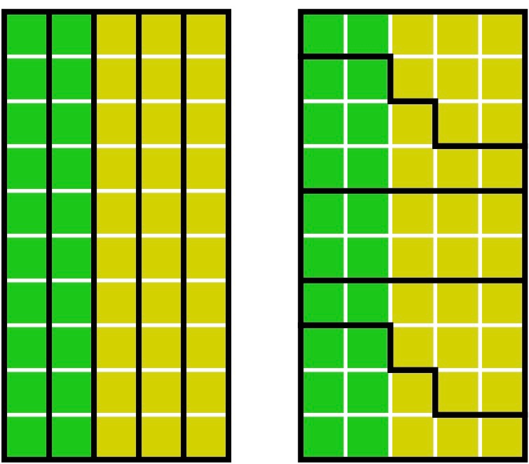
The districting on the left offers geometric simplicity and yields results that are politically proportional to population. The one on the right, though more complex geometrically, gives the same proportionate outcome.
Who’s Mr. Gerrymander Anyway? Actually, he’s Elbridge Thomas Gerry, a Democrat-Republican contesting against Federalists back in post-Revolutionary days. The “mander” comes from a potential resemblance to a salamander.
Gerry was among the Founding Fathers who signed the Declaration of Independence, but refused signing the original U.S. Constitution until it contained its first ten amendments, the Bill of Rights.

Gerry was the ninth Governor of Massachusetts, 1810–1812, after a particularly acrimonious campaign against the Federalists. As described in Wikipedia, “In 1812 the state adopted new constitutionally-mandated electoral district boundaries. The Republican-controlled legislature had created district boundaries designed to enhance their party’s control over state and national offices, leading to some oddly shaped legislative districts. Although Gerry was unhappy about the highly partisan districting (according to his son-in-law, he thought it ‘highly disagreeable’), he signed the legislation.”
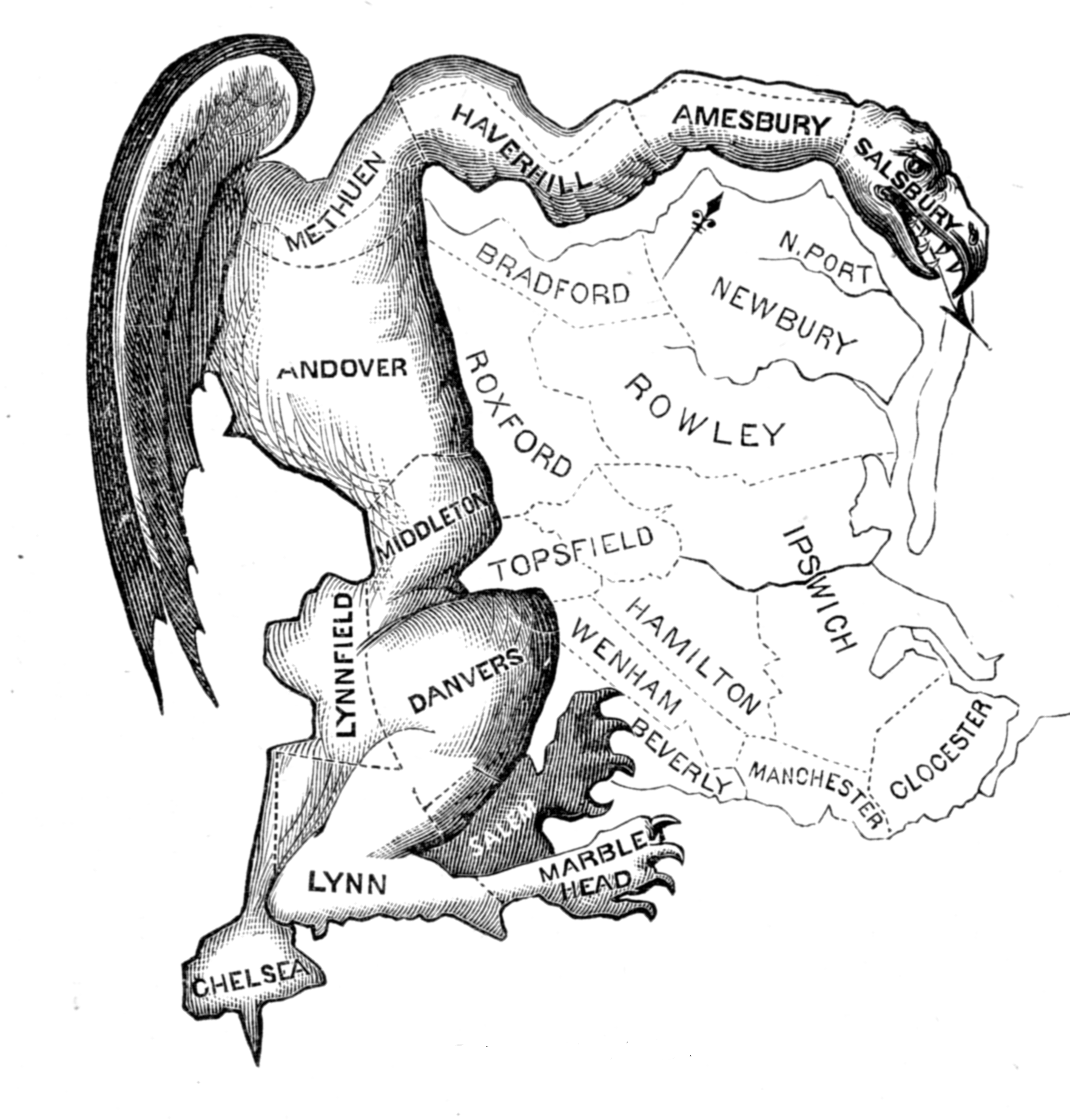
Wikipedia writes that this political cartoon “depicts a state senate district in Essex County as a strange animal with claws, wings and a dragon-type head, satirizing the district’s odd shape.”
How the Game is Played. The 435 U.S. Congressional Districts are apportioned by states based on population counts after decennial censuses (thus, the importance of a fair and complete count). Each district’s population is to be approximately equal to others in a state. A district must be contiguous (i.e., one-piece), though state legislatures can employ, let us say, artful geometry.
Bizarre Gerrymandering. One of my favorites was Pennsylvania’s 7th Congressional District (until its state supreme court ruled otherwise). NPR called Pennsylvania’s 7th “an egregious example of gerrymanding.” The Washington Post listed it as “one of the ten most gerrymandered districts in the country.”
High praise indeed. Others called Pennsylvania’s 7th “Goofy Kicking Donald Duck.”

Another favorite, before being court-ordered otherwise in 2017, was North Carolina’s 12th Congressional District. This one snaked down Interstate 85 so closely that a North Carolina legislator quipped, “If you drove down the interstate with both doors open, you’d kill most of the people in the district.”
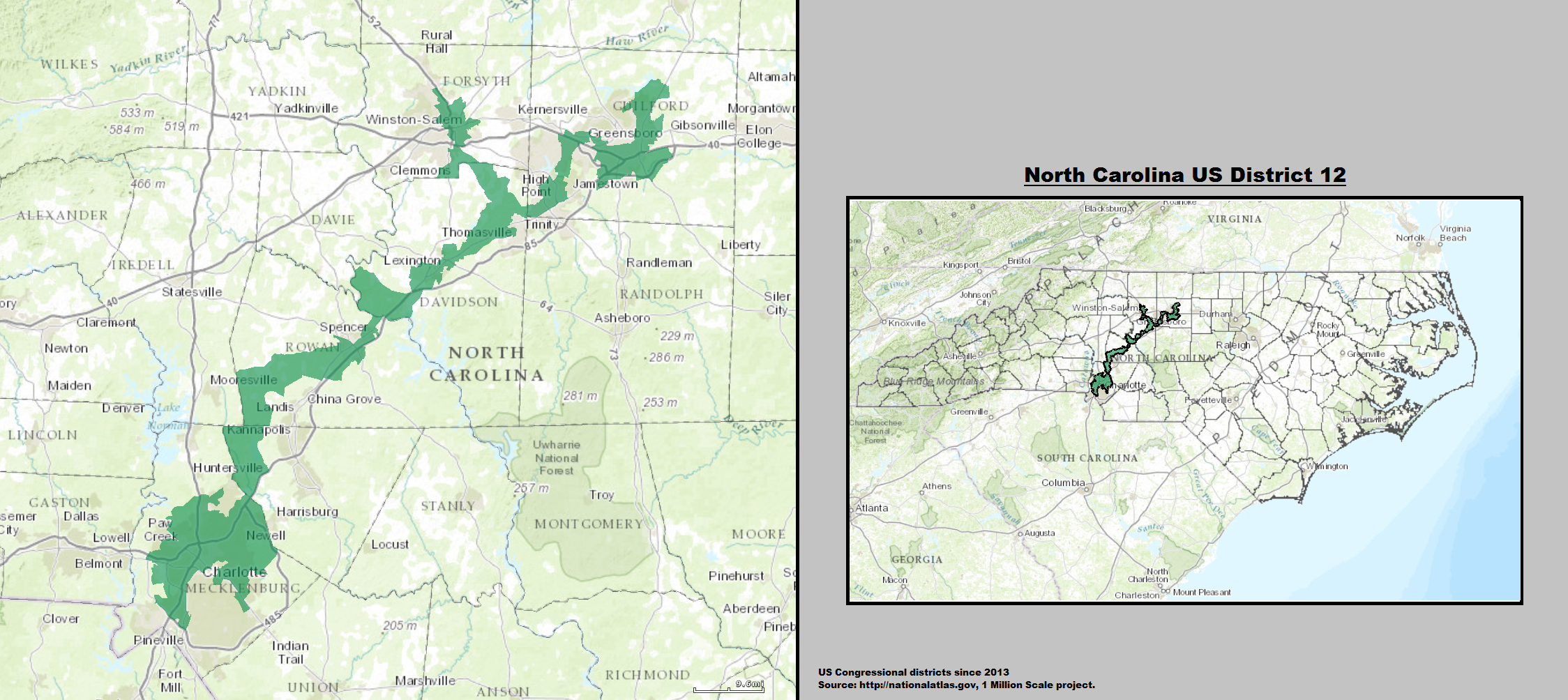
Justice Elena Kagan noted that the 2017 decision was the fifth time that North Carolina 12th had appeared before the Supreme Court.
The Supreme Court Now Washes Its Hands of the Matter. On June 27, 2019, in a 5-4 decision the U.S. Supreme Court ruled that extreme partisan gerrymandering is still unconstitutional, but it’s up to Congress and state legislative bodies to resolve the problem.
Don’t wait up nights. ds
© Dennis Simanaitis, SimanaitisSays.com, 2020

Even when not explicitly gerrymandered, things can look pretty strange. Check out California Congressional Districts: https://www.zipdatamaps.com/politics/national/districts/map-of-california-congressional-districts
California districts are theoretically done fairly, by a commission rather than the legislature directly. Doesn’t keep things from being set up to make districts pretty safe for one party or the other.
Another issue, though, is the number of districts – related to the number of Congresscritters. The House hasn’t been increased in size for a long time, despite the population rising. So each Representative represents many more people than in the past. That pretty much guarantees districts that are somewhat head-scratching in layout. Oh well…